 FERC just directed Sabal Trail to actually address problems raised
by citizens and local government agencies, plus numerous discrepencies
FERC itself detected.
Opposition to this unnecessary and hazardous fracked methane
pipeline is having effects, even with rubberstamping FERC.
But watch out Tifton, Valdosta, Thomasville, and The Villages!
You’re now on possible routes.
FERC just directed Sabal Trail to actually address problems raised
by citizens and local government agencies, plus numerous discrepencies
FERC itself detected.
Opposition to this unnecessary and hazardous fracked methane
pipeline is having effects, even with rubberstamping FERC.
But watch out Tifton, Valdosta, Thomasville, and The Villages!
You’re now on possible routes.
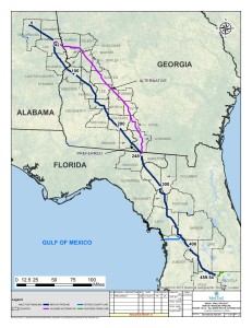
Sabal Trail is to provide details for Greenlaw’s route-around-Albany proposals on behalf of Sierra Club and others Valdosta, you’re back in two proposed routes, the the one you saw last summer, plus one down I-75 that would go right past Lowndes High School and also past The Villages in sinkhole-prone Sumter County, Florida. Tifton, you’re not safe; look at that Hillabee route. Thomasville watch out: you’re on a new proposed route.
 Sabal Trail is to provide alternatives to minimize effects on or
completely avoid the
Withlacoochee River,
and this is even before the Hamilton County Commission’s resolution
against the pipeline gets to FERC.
Sabal Trail is to provide alternatives to minimize effects on or
completely avoid the
Withlacoochee River,
and this is even before the Hamilton County Commission’s resolution
against the pipeline gets to FERC.
FERC’s letter is peppered with requirements to cooperate with federal, state, and local agencies especially including about land use and environmental requirements and land approvals.
 It explicitly says that
all surveys
have to accurately
address the final proposed facilities.
Which means that
even a few landowners refusing surveys and first offers and
saying
saying
Come and Take It
do matter.
It explicitly says that
all surveys
have to accurately
address the final proposed facilities.
Which means that
even a few landowners refusing surveys and first offers and
saying
saying
Come and Take It
do matter.
While FERC’s letter reads like massive CYA so Sabal Trail can keep “moving forward”,
all this is a welcome change from last December at Sabal Trail’s open
house in Madison, Florida, when the FERC reps I talked to knew nothing
about karst limestone or sinkholes or the Floridan Aquifer.
![]() Now FERC wants to know how
blasting
or
drilling under a river
could trigger sinkholes,
which
sinkhole databases Sabal Trail has consulted,
a depth limit for investigations in sinkhole-prone areas where
subsidence could occur.
And what about that
Hildreth compressor station
proposed in a sinkhole-prone area
in Suwannee County, Florida.
Now FERC wants to know how
blasting
or
drilling under a river
could trigger sinkholes,
which
sinkhole databases Sabal Trail has consulted,
a depth limit for investigations in sinkhole-prone areas where
subsidence could occur.
And what about that
Hildreth compressor station
proposed in a sinkhole-prone area
in Suwannee County, Florida.
Plus
how far can a pipeline support itself across a sudden sinkhole,
 like the notorious 25-acre
Assumption Parish sinkhole in Louisiana that caused FGT to move its pipeline.
And remember, FGT called that force majeure, as in not their fault,
which would mean if Sabal Trail did the same thing, the taxpayers would
end up paying for any sinkhole-caused leaks or explosions.
like the notorious 25-acre
Assumption Parish sinkhole in Louisiana that caused FGT to move its pipeline.
And remember, FGT called that force majeure, as in not their fault,
which would mean if Sabal Trail did the same thing, the taxpayers would
end up paying for any sinkhole-caused leaks or explosions.
Doing all this work is going to cost Sabal Trail heaps of money, especially doing it in the 20 days FERC allowed. Maybe enough that Spectra will decide it’s just not worth it, like it just did with that pipeline from Pennsylvania through Virginia to North Carolina and like Williams Company did with its Bluegrass Pipeline from Ohio to the Gulf coast back in April.
Filed by FERC 26 August 2014, Letter to Sabal Trail Transmission LLC providing the Staff’s comments on the Draft Resource Reports 1, 6, 9, 10, and 11 for the Sabal Trail Project under PF14-1.
FEDERAL ENERGY REGULATORY COMMISSION
WASHINGTON, D.C. 20426
OFFICE OF ENERGY PROJECTS In Reply Refer To:
OEP/DG2E/Gas Branch 3
Sabal Trail Transmission, LLC
Sabal Trail Project
Docket No. PF14-1-000
August 26, 2014
Ms. Lisa A. Connolly
General Manager, Rates and Certificates
Sabal Trail Transmission, LLC
5400 Westheimer Court, Suite 6N61
Houston, TX 77056
Re: Staff’s Comments on Draft Resource Reports 1, 6, 9, 10, and 11
Ms. Connolly:
Please find enclosed comments on Sabal Trail Transmission, LLC’s (Sabal Trail) draft Resource Reports 1, 6, 9, 10, and 11. Unless otherwise indicated, address these comments in the final resource reports to be filed by Sabal Trail. Also, to increase the efficiency of our review, the final resource reports should include a matrix indicating where these comments are addressed and a schedule for submittal of any requested information that is not included.
Thank you for your cooperation. If you have any questions, please contact me at (202) 502-6352.
Sincerely,
John Peconom
Environmental Project Manager
Office of Energy Projects
Enclosure
cc: Public File, Docket No. PF14-1-000
ENCLOSURE
Sabal Trail Project
Docket No. PF14-1-000
Federal Energy Regulatory Commission
Comments on Draft Resource Reports 1, 6, 9, 10, and 11
Provide the following information within 20 days of the issuance of the letter:
As described in the Sierra Club – Georgia Chapter (GreenLaw) comment letter filed with the Federal Energy Regulatory Commission (FERC, or Commission) on April 21, 2014, include analyses of four major route alternatives between approximately mileposts (MPs) 0 and 460.6:
Alternative 1 extending from near MP 0 to MP 460.6 (the proposed endpoint) following the Sabal Trail Transmission, LLC (Sabal Trail) proposed Sabal Trail Project (Project) route until reaching Highway 82 near Dawson, Georgia; then following Highway 82 to Interstate 75 (I-75); then following I-75 to Highway 91 near The Villages, Florida; then following Highway 91 to Highway 27 near Ferndale, Florida; and then following a Florida Gas Transmission (FGT) pipeline to the proposed endpoint.
Alternative 2 extending along other pipeline and road rights-of-way from near MP 0 to approximately MP 141 (near Albany, Georgia), and then following Alternate 1 to the proposed endpoint.
Alternative 3 beginning at approximately MP 141 (near Albany, Georgia) and following Highway 82 to Highway 19 (Slappy Boulevard) in Albany, Georgia; then following Highway 19 through Albany, Camilla, and Thomasville, Georgia to the FGT pipeline corridor south of Capps, Florida; then following the FGT pipeline corridor to I-75 and the Alternate 1 and 2 routes to the proposed endpoint.
Alternative 4 beginning from Alternate 2 near Richland, Georgia and following Highway 280 to near Americus, Georgia; then following a high voltage transmission line (along Sabal Trail’s Hillabee Alternative route); then following Alternate 1 starting near Tifton, Georgia and extending to the proposed endpoint.
As described in letters filed with the Commission by Ms. Mary Ellen Tatum on April 1 and July 28, 2014, Mr. Ken Fleming on April 21, 2014, and multiple comment letters submitted by Hannah, Deanna, and Christopher J. Mericle in July and August 2014, include analyses of route alternatives in Hamilton and Madison Counties, Florida that avoid or reduce impacts on sensitive springs and mature trees located adjacent to the Withlacoochee River, and/or avoid crossing the Withlacoochee River. These analyses should include routes that would:
follow existing transmission line, pipeline, and road (i.e., Southwest 40th Avenue) rights-of-way located east of the proposed route between approximately MPs 249.3 and 266; and
follow existing transmission line and interstate road rights-of-way located west of the proposed route between approximately MPs 255 and 260.
Draft Resource Reports – General Comments
The FERC staff recognizes that Sabal Trail is continuing to work with landowners, agencies, and other parties in refining proposed workspaces and other elements of the planned Project. Regarding Sabal Trail’s final proposal, ensure that:
the final resource reports (RRs), alignment sheets, and all other associated plans and drawings accurately and consistently depict and quantify the construction and operational land use requirements and environmental impacts of the final proposed facilities;
all surveys and other associated studies address the final proposed facilities;
Sabal Trail’s construction, restoration, and mitigation plans address the final proposed facilities; and
federal, state, and local agencies are informed of the final proposed facilities, and documentation of all agency consultations, approvals, etc., pertaining to the final facilities is provided.
Relatively minor discrepancies in counts, lengths, acreages, and other dimensioned elements were noted between various tables, text, and drawings throughout the draft RRs, some examples of which are included in comments on individual draft RRs. Ensure that all counts, correlative lengths, acreages, and drawings are correct and consistent throughout the final RRs.
Provide in the final RRs all appendices, site-specific plans, agency correspondence, and other documents that were not provided in the draft RRs. Some examples are included in comments on individual draft RRs.
Ensure that the final RRs address all substantive comments received, including resource-specific comments provided by resource agencies during project planning. Provide copies of consultations, meeting summaries, relevant telephone conversation summaries, and relevant email communications submitted to and received from agencies.
Draft Resource Report 1 – General Project Description
Include a table that lists all of the stand-alone environmental plans and procedures related to the construction and operation of the Project that Sabal Trail has or would prepare (e.g., Sabal Trail’s Erosion and Sediment Control Plan [ESCP], Blasting Plan, Invasive Species Management Plan, Unanticipated Discovery Plan, Spill Prevention and Containment Plan, Horizontal Directional Drill [HDD] Plan). Provide the location of each plan in the final RRs or other application materials, or the schedule for submittal of any plans not included in the final RRs. Also identify any federal, state, or local agencies that would review and/or approve the plans and the status of agency review/approval.
Describe any corrosion control facilities (e.g., cathodic protection) necessary to operate the planned pipelines. Include land requirements and locations of any corrosion control facilities located outside the planned operational right-of-way; include their review throughout the final RRs; and include these facilities in the consultation and permitting review of the Project.
Include in table 1.2-2 a summary of all the mainline valves and blow down valves, including information about where blow down valves would be located outside the operational right-of-way for the pipeline.
Include a description of the purpose of the Hunter’s Creek line in section 1.2.
Clarify in section 1.1 the capacity that would be available upon the addition of compression in 2020.
Include a description of why the pipeline centerline would be generally offset 15 feet from one edge of the 50-foot-wide operational right-of-way, rather than centered within the operational right-of-way.
Justify the need for a 90-foot-wide construction right-of-way for the Citrus Lateral.
Include the acreage that would be acquired for each compressor station site in table 1.5-3.
Include in a revised table 1.5-2 the amount of acres of proposed temporary construction right-of-way and operational right-of-way that would overlap existing maintained easements, such as adjacent powerline or pipeline rights-of-way. Include in section 1.5.1.3 the total acreage of temporary and permanent rights-of-way that would overlap existing rights-of-way.
In section 1.6.1.1:
clarify when civil survey would occur and whether or not areas would need to be re-staked following clearing; and
under ROW and Temporary Construction Workspace Grading, clarify:
what are the general types of areas where the construction right-of-way is limited and topsoil would need to be stockpiled off-site;
what type of imported material would be used to replace topsoil;
that rough grading the entire right-of-way would not conflict with leaving rootstock in place in wetlands; and
that grading activities would be limited to uplands and unsaturated wetlands.
Identify in section 1.6.1.4 areas that are “too steep” to install temporary trench and slope breakers safely or adequately, and confirm this would be a modification from section IV.F.1 of the FERC Upland Erosion Control, Revegetation, and Maintenance Plan. Include site-specific justifications for each location that would be too steep.
Confirm that the statement “the depth of the pipeline in these areas may vary below USDOT minimum standards” means that the pipeline may be buried deeper than required by the U.S. Department of Transportation (USDOT).
In section 1.6.1.6, under HDD Crossing Method, clarify what agency has classified drilling mud as non-toxic to the aquatic environment. In addition, identify any other additives that may be used in drilling mud other than bentonite clay, and verify that these additives would not have an adverse effect on water resources in the event of a release of drilling mud.
In section 1.6.1.6, confirm that Sabal Trail would identify in advance those locations where trench spoil could not be stored at least 10 feet from a waterbody edge and include site-specific justifications for each location where this would occur.
Provide in section 1.6.1.7 a general description of concrete coating activities and any other measures that would be used to reduce pipeline buoyancy. In addition, confirm that refueling, parking, hazardous material storage, and concrete coating activities would be setback a minimum of 100 feet from wetlands, including wetlands that are dry enough at the time of construction to support skids and pipe.
Include in section 1.8 an estimate of the approximate length of time between initial staking to final cleanup along the pipeline right-of-way, and describe the typical length of time the trench would be open at a given location along the Project route.
Confirm that routine vegetation mowing or clearing would not be conducted between HDD entry and exit points.
Include in section 1.11.1.1 the protocols to identify and address landowner complaints during and after construction. Include a description of when and how Sabal Trail would communicate its Landowner Complaint Resolution Process to landowners prior to construction.
Include in section 1.11 the locations where hard copies of the final RRs would be made available to be viewed by the public along the Project route.
Revise table 1.12-1 to include the dates when permit applications have been or are expected to be submitted and the dates when permits have been or are expected to be issued. Include similar dates for initiation and completion of referenced agency consultations and reviews. In addition, confirm that Sabal Trail would provide an updated permit table approximately every 60 days between submittal of the FERC application and issuance of the final Environmental Impact Statement.
Include in section 1.14 a description about each non-jurisdictional facility site including ownership, land requirements, size (e.g., gas consumption, megawatts), current environment (e.g., land use, vegetative cover, adjacent facilities, land ownership), construction status, and status of local, state, and federal approvals. Also provide a scale topographic map depicting the location of the facilities.
Include in section 1.15 a cumulative impact analysis of the new and retired facilities described in section 1.2, including:
Duke Energy Florida’s two new Suwannee Plant combustion turbines near Live Oak, Florida;
new equipment to be installed at the Hines Energy Complex near Bartow, Florida; and
retirement of two coal-fired units at the Crystal River Energy Complex located in Citrus County, Florida.
Confirm that FERC would be notified of an off-right-of-way disturbance event during construction and update section 3.5 of the ESCP (located in appendix 1B of draft RR 1) to reflect the need for this notification.
Include a description of why equipment bridges would not be required in non-state designated waterbodies, as indicated in table 5-1 of the ESCP (located in appendix 1B of draft RR 1). If applicable, include a request to modify the requirements for equipment bridges as identified in section V.B.5 of the FERC Procedures and provide a site-specific justification for each location.
Include a Fire Prevention and Suppression Plan that identifies strategies to facilitate immediate actions to extinguish or control any construction-related fires and the strategies to control and monitor any Project-related burns. The plan should establish protocols and lines of communication for reporting fires, describe the fire equipment that would be present during all Project-related burns, and outline any fire training that would be provided to Project personnel.
Draft Resource Report 6 – Geologic Resources
For all figures in RR6, identify the source(s) of information used to create each figure.
In section 6.2.1, include a description of the karst terrain underlying the Project facilities in Georgia and Alabama.
Include the data sources used to identify the mineral resources located near the Project.
Include a discussion of blasting as a mechanism for triggering sinkhole development; and any measures (restrictions) Sabal Trail would implement to minimize this impact. Also, include a description of how impacts would be assessed and mitigated.
In section 6.4, include:
citations for the government mine databases;
the date range for the aerial photographs that were reviewed;
a discussion of whether filed mineral claims, prospects (e.g., there are three listed in table 6.4-1), or rights exist within the Project area;
a discussion of whether or not (and where) undeveloped oil and gas resources are within the Project area;
documentation of communication with owners/operators of any mines or mine leases that would be crossed and any issues identified by the owners and operators; and
a discussion of the potential for the Project to hinder mine reclamation efforts or future expansion.
Regarding the karst information depicted on maps 1 and 2 of figure 6.5-1, include:
a description of each karst region identified in the text of the RR and correlate the various regions depicted in each state; and
relate and incorporate the karst regions depicted on figure 6.5-1 to the discussion of karst sensitive areas in section 6.5.1.1.
In section 6.5.1 include a summary of consultations Sabal Trail conducted with geologists/speleologists from the Florida Geologic Survey or Water Management Districts, and the karst-related studies and databases (e.g., dye traces, mapped karst joints, fracture networks, or caves) from these agencies that were used in the analysis of karst conditions and issues in the Project area. Also, include this information for Georgia and Alabama.
In section 6.5.1:
for the river crossings depicted in figure 6.5-2, and where maps are available that show known conduit and cave systems, plot those features relative to proposed HDD drill paths to document the proximity of the borehole to the conduit and cave networks;
include a discussion of whether there is a conduit size or fracture density limitation for determining the appropriate use of HDD;
reconcile the discrepancy between figure 6.5-1, which appears to indicate there are no karst regions crossed by the Project in Alabama, and table 6.5-1, which lists karst features in Alabama between approximate MPs 72 and 82;
include citations for the Florida, Georgia, and Alabama sinkhole databases that were consulted, and summarize the sinkhole dimensions (average and maximum diameter, depth, etc.) reported in the databases; and
ensure that tables 6.5-1 and 6.5-2 include karst features identified in comment letters/transcripts.
Regarding the Cardno Entrix report provided in appendix 6B:
clarify whether the term “sensitive” applies to the actual triggering of karst development, to exposure of the Floridian Aquifer to pollution, to both, or other factor(s);
define the approximate width of the karst survey corridor relative to the centerline of the pipelines and boundary of aboveground facilities, and justify the appropriateness of this area of study;
define the depth limit for which proposed field investigations would take place to evaluate the underlying karst considering Sinclair and Stewart (1985) note that 200 feet of cover may overlie sinkhole-prone areas; and
resolve the discrepancy between routing the pipeline through mapped fracture traces and fracture trace intersections within Madison, Suwannee, and to a lesser extent Gilchrist Counties, Florida and the statement in the Cardno Entrix (2014) report in appendix 6B that “an enhanced degree of caution” should be exercised when the proposed pipeline route crosses fracture traces because these areas could be prone to subsidence during construction or sinkhole formation, or could serve as pathways for sediment and contaminants to enter the Upper Floridian aquifer.
Include in section 6.5.1.1 a discussion of structural integrity concerns for the Albany, Georgia and Hildreth, Florida compressor stations, which are listed in table 6.5-2 as being located within the footprint of sinkholes.
In section 6.5.1.2:
Identify when field investigations would be completed and when the resulting data and conclusions would be made available;
discuss the measures Sabal Trail would implement (e.g., reducing mud viscosity) to reduce the potential for HDD drilling mud to be released into conduit or cave systems should there be a loss of returns during drilling;
discuss how HDD may affect or trigger sinkhole development (i.e., see Smith and Sinn, 2013, http://www.karstportal.org/sites/karstportal.org/files/KIP-00011809.pdf), and describe the measures that would be implemented to evaluate the potential for this to occur;
where it is stated that “Buffer zones of 300 feet will be established around karst features in all work areas,” clarify if a “karst feature” in this instance would refer to a surficial expression only or if it also includes buried or mantled karst features that are found through geophysics or other investigative methods;
include the distance the pipeline could cross unsupported for each class of pipe that would be installed, and discuss relative to the typical width of sinkholes likely to be encountered based on the sinkhole database data, and/or field investigations (i.e., see Nel and Haarhoff, 2011, http://www.civils.org.za/Portals/0/pdf/journal/vol53-1-2011/vol53_n1_b.pdf); and
discuss the adequacy of using a concrete plug while maintaining groundwater quality where the potentiometric surface of the underlying groundwater is present within a sinkhole.
Address the potential for paleontological resources to occur in the Project area, including classification, location in the Project area, inspection, and reporting of finds.
Draft Resource Report 9 – Air and Noise Quality
Include detailed descriptions of the heaters that would be installed at the meter and regulation stations identified in section 9.2.2 (e.g., energy consumption, estimated emissions).
Include in section 9.2.5:
a summary of applicable state air emission regulations, particularly those that differ from federal regulations and those that impose more stringent or unique restrictions (such as emission limitations); and
a discussion of how Sabal Trail would comply with these regulations (e.g., how the Project would meet Nitrogen Oxide (NOx) emission limits).
For compressor stations requiring a Prevention of Significant Deterioration Review, consult with the Federal Land Manager of the nearest Class I area and confirm that Class I area modeling would not be required.
Assess and describe the feasibility of installing heat recovery on the compressor engines/turbines.
Include in section 9.2.6 an air quality screening (AERSCREEN) analysis of NOx and Carbon Monoxide impacts at each compressor station to demonstrate that emissions of criteria pollutants would not result in exceedance of the National Ambient Air Quality Standards (NAAQS) or state standards. Include all input parameters (e.g., emission rate, stack height, stack temp, exit velocity) and justify the bases for any assumptions. For any facility requiring refined modeling for an air permit (using AERMOD or U.S. Environmental Protection Agency (EPA)-approved alternative), provide the modeling protocol, a narrative describing and justifying the modeling basis all inputs (MET data, terrain data), and all input/output files.
In light of the recent U.S. Supreme Court decision on the EPA’s greenhouse gas Tailoring Rule (June 23, 2014; No. 12–1146), update if necessary the discussion of New Source Review in section 9.2.5.1.
Confirm that pipeline construction activities – with the exception of HDDs, tie-ins, and purging and packing the pipeline – would be limited to daytime hours.
Identify in section 9.3.4.3.2 the approximate number of days required to complete HDD operations at each site and the direction and distance to the nearest noise sensitive area from each HDD site. In addition, confirm that HDD operations could occur 24 hours per day and include an HDD noise mitigation plan that would be implemented if 24-hour HDD operations are required. The plan should include:
a residential complaint process should HDD noise become a nuisance;
a description of noise mitigation measures that Sabal Trail would implement; and
procedures to monitor, document, and report noise levels during HDD operations. The reports should be included in Sabal Trail’s biweekly construction reports to FERC.
Draft Resource Report 10 – Alternatives
Analyze the feasibility of an alternative(s) that includes, but is not limited to, utilizing trucks and/or rail to transport the proposed volumes of natural gas between Transco’s Station 85 in Alabama and the proposed Central Florida Hub in Florida.
In response to comments raised by a potentially affected landowner, include a route alternative beginning at approximately MP 141 that would continue along the existing Southern Natural Gas (SONAT) pipeline for another approximately 1,000 feet before deviating south as currently planned.
Include a route alternative analysis that would follow the existing SONAT pipeline past MP 142 through northeast Albany, Georgia instead of deviating to the southwest around Albany.
Include in the Moultrie Alternatives analysis, the following easterly route deviations:
beginning at approximately MP190.5 heading east for approximately 2 miles and then turning south to rejoin the planned route at approximately MP 193.5; and
beginning at approximately MP 190.8 heading east for .04 mile and then turning south to rejoin the planned route at approximately MP 191.2.
Ensure that the Wacassassa Flats route alternative analysis is updated to compare the Gilchrist County Board-recommended route to the currently proposed route (i.e., Gilchrest Westerly Alternative) between approximately MPs 315 and 334.
Identify in the Gulf Hammock route alternative analysis the recreation and special interest areas crossed by the proposed route and the alternative route. Additionally, depict the state forest boundary (and any other public lands) that would be crossed on figure 10.5.1-10.
Include the information sources used for each factor evaluated in tables 10.5.1-2a, 10.5.1-3, and 10.6-1 through 10.6-4.
Include in tables 10.5.1-4 through 10.5.1-12, comparisons of:
construction and operation impacts on forested wetlands (in acres);
length (in feet) of springsheds crossed;
number of 1st, 2nd, and 3rd Order springs within 0.5 mile of each route in Florida, and the number of springs within 0.5 mile of each route in Alabama and Georgia;
length of karst regions crossed (i.e., using the state-specific data depicted in figure 6.5-1 of draft RR 6 as the source for the comparative factor);
distance from mapped fracture traces and fracture trace intersections where fracture permeability may be enlarged through dissolution of the bedrock into conduit-cavernous porosity/permeability; and
the distance each alternative is hydraulically upgradient from known springs to take advantage of the potential for diffuse or fracture permeability.
Include in I-75 route alternative analysis a general description of where the route would be located relative to I-75 (e.g., east or west and distance from the interstate). In addition, include a characterization of the development that would be crossed (e.g., number of cities crossed) and discuss the feasibility of locating the pipeline within the existing I-75 right-of-way. As applicable, summarize any consultations with the Florida Department of Transportation regarding this alternative.
As described in the Audubon-Florida and the Southwest Florida Water Management District (SWFMD) comment letters filed with the Commission on March 26 and April 21, 2014, respectively, concerning the Halpata-Tastanaki (HT) Preserve in Marion County, Florida include analyses of route alternatives that would:
avoid affecting the HT Preserve by following County Road 484 (north of the HT Preserve) to State Highway 200, and then extend southeasterly to interconnect with the existing high-voltage powerline corridor located east of the Ross Prairie State Forest;
avoid affecting the HT Preserve by departing from the proposed route where it crosses State Highway 41 north of Dunnellon, at approximately MP 367, then extends easterly approximately 8 miles to SW 110th Avenue, then turns southerly to cross County Road 484, then turns easterly and travels along the north edge of the Cross-Florida Greenway property across State Highway 200, then turns southerly for approximately 3 miles, and then continues easterly for approximately 3 miles to intersect the existing high-voltage powerline corridor east of the Ross Prairie State Forest; and
minimize impacts on the HT Preserve by following the north edge of the Cross-Florida Greenway within the HT Preserve, continuing easterly across State Highway 200, and then extending southeasterly to interconnect with the existing high-voltage powerline corridor east of the Ross Prairie State Forest.
For each HT alternative, include comparative factors that are consistent with those used in table 10.5.2-10. In addition, include, as applicable, the length of crossing or collocation with and figures that depict the boundaries of:
the HT Preserve;
restoration areas within the HT Preserve (e.g., scrub jay habitat, flood control areas, wetland banking sites);
the Cross-Florida Greenway; and
the Ross Prairie State Forest.
Lastly, include a summary of consultations with the SWFMD; and an assessment of whether or not the Project route could be integrated to support the state and local trail planning efforts through the HT Preserve along the Cross-Florida Greenway.
Include in the Sasser route deviation analysis a comparison of wetland impacts along greenfield portion(s) of the proposed route and the greenfield portion(s) of the route alternative. Also, identify recreation and special interest areas crossed.
As described in multiple comment letters provided by landowners in the Happy Trails Community in Osceola County, Florida, include an analysis of route alternatives considered to avoid or minimize impacts on residences, forests, and wetlands between approximately MPs 454.5 and 458.3. This analysis should include routes extending north and east, and west and south of the Happy Trails Community.
As described in the Bill and Nanci Kendall letter filed on August 12, 2014, include an analysis of the route they identified to avoid or minimize impacts on residences near Valdosta, Georgia. In addition, provide justification for any proposed deviation from the existing SONAT Pipeline corridor in the vicinity of Phillips Road.
Revise the information presented in tables 10.5.3-1, 10.5.3-2, and 10.5.3-3 such that these route variations are presented in order by MP (not by reroute name) and include affected tract numbers.
Include in the Rails to Trails route alternative analysis a discussion of construction techniques that could be used to install the pipeline along the General James A. Van Fleet State Trail. Include in this analysis use of the push-pull method using the rail bed as a working platform to install the pipeline directly adjacent to the bike trail. Also, identify the amount (acres) of forest and forested wetland impacts in table 10.5.1-12.
Include an analysis of a route alternative that would collocate the pipeline with an existing powerline right-of-way at approximately MP 425 (Highway 50 crossing) and then return to the planned pipeline route around MP 436.
Ensure that the “reasons for elimination” included in table 10.5.3-3 are of sufficient detail to demonstrate why route variations were not incorporated into the planned route. Also, include a brief description of the reason(s) that reroute 1 (MP range 165.2 to 168.4) was “canceled”.
Include for each proposed compressor station site the upstream and downstream distances that would meet the hydraulic flow requirements of the Project.
Include a discussion of the feasibility of using electric-driven compressor units as an alternative to the proposed natural gas-fired compressors. This discussion should include the following information for any associated non-jurisdictional electric transmission facilities:
an estimate of the length, acreage, phase, and voltage of any powerline(s) that would be constructed to provide electricity to compressors units;
an estimate of the average height of the structures;
the acreage and land use types (e.g, forested, industrial, residential) that would be affected by construction of any non-jurisdictional facilities resulting from electric compression;
a list of federal and state environmental permits required; and
the potential impacts on environmental resources (e.g., visual, wetlands, and vegetation).
For each compressor station alternative site identified, identify the amount of land that would be fenced and the amount of land that would be directly disturbed by construction activities. Include descriptions of the activities affecting lands at these sites and identify the amounts of land necessary to conduct these activities. Also, identify the footprint (in square feet and/or acres) of each planned compressor station.
Include in the compressor station alternatives analysis, for each planned compressor station site and alternative sites:
demographic information (racial, ethnic, and poverty rates) at the census tract/block level for the areas around each site that extends to the point in which the potential change in ambient noise level would not be perceptible;
the amounts (in acres) of agricultural land that would be impacted by construction and operation of these facilities;
plot plans for each site that depict where facilities would be located within each site, how each site would be accessed, and anticipated lateral pipeline locations; and
figures depicting a 0.5-mile buffer around each compressor station, and the nearest noise sensitive area(s) and their distance from each compressor station.
Include analyses of Hildreth Compressor Station alternatives near the FGT meter station at approximately MP 296b and between MPs 297 and 300.
Include analyses of Albany Compressor Station alternatives at approximately MPs 156.5 and 159.
Draft Resource Report 11 – Reliability and Safety
Confirm that Sabal Trail would install the proposed pipelines with a minimum of 36 inches of cover including in areas with consolidated bedrock. Also, identify the locations where the burial depths would exceed 36 inches.
In section 11.4.8 discuss how Sabal Trail would maintain emergency vehicle access to nearby residences during construction of the proposed facilities.
In section 11.4.14, discuss how Sabal Trail would protect existing utilities from potential damage due to blasting operations.
Generally describe the design features and operational procedures that would be implemented to ensure the reliability and safety of the proposed compressor stations.
In section 11.4.15.5, discuss the effectiveness of the corrosion control systems that would be implemented to protect the pipeline in wetlands and other areas with a shallow water table.
-jsq


